This is the description of the 2001 October 15 FIRST catalog. It has been replaced by a newer catalog. Old released versions of the FIRST catalog are made available for archival purposes for the benefit of those who have already started research programs based on those catalogs. The newest version is always preferred for new projects.
See the catalog history for information on changes in the various FIRST catalogs.
catalog_01oct15.bin.gz).
The file size is 25.2 Mbytes compressed (83.3 Mbytes uncompressed).
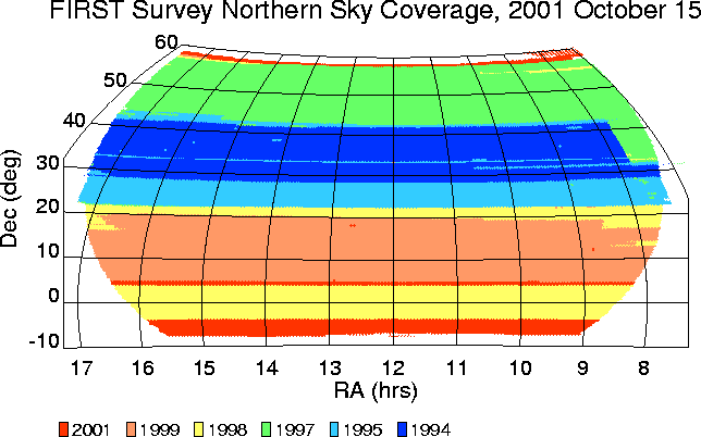
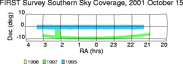
The catalog covers a total of about 8565 square degrees of sky (7954
square degrees in the north Galactic cap and 611 square degrees
in the south Galactic cap.)
See the coverage maps for more details of the area covered. Both the northern and southern areas were chosen to concide the area planned to be covered by the Sloan Digital Sky Survey. No new data were taken for the south Galactic cap during the past observing season, so the current catalog is practically identical to the previous catalog in the south.
For this version of the catalog, most of the maps constructed from the previous round of observations (in 1999) were remade to correct a small error in the annual aberration correction (due to a Y2K error in the observation date string.) This led to numerous small changes in the positions and flux densities for sources in the area covered by the 1999 observations. The differences are generally much smaller than the uncertainties: the mean position shift is 0.032 arcsec and the mean flux change is 0.015 mJy, though in rare cases they can be larger.
The catalog is on-line and can be searched using the FIRST Search Engine. However, for large-scale investigations it will be necessary to obtain the complete catalog. This document describes the catalog format.
The catalog is sorted by right ascension and has the following format:
    RA  (2000)   Dec      W    Fpeak      Fint    Rms     Maj    Min    PA   fMaj   fMin   fPA Field Name
06 50 44.043 +31 10 00.09       1.16      0.64   0.147   0.00   0.00  42.0   4.50   3.59  42.0 06510+31143E
06 51 02.181 +31 11 13.33       1.58      2.66   0.139   4.99   3.94  91.6   7.35   6.69  91.6 06510+31143E
06 51 03.826 +31 13 03.32 W     1.02      1.42   0.137   7.63   0.00   2.4   9.35   4.34   2.4 06510+31143E
06 51 06.134 +31 19 02.00       7.29      9.64   0.145   4.09   1.82 131.3   6.77   5.70 131.3 06510+31143E
06 51 10.784 +31 11 28.80      72.36    100.79   0.141   4.18   2.49   9.8   6.83   5.95   9.8 06510+31143E
Note that this format is the same as the most recent versions of the catalog
but has changed from the oldest versions.
unc(90% confidence) = Size (1/SNR + 1/20) arcsecwhere Size is either the major or minor axis fitted FWHM (fMaj or fMin) as given in the catalog and SNR is the peak flux density signal-to-noise ratio:
SNR = (Fpeak-0.25) / Rms(The positional uncertainty is of course elliptical for elliptical sources.) The best possible positional uncertainty is limited to about 0.1 arcsec by our ability to fit source positions in maps with 1.8 arcsec pixels and by various random calibration uncertainties. Systematic errors in the positions are smaller than 0.05 arcsec.
IMPORTANT NOTE: The sidelobe flagging near and south of the equator is not as reliable as in the north because the sidelobe characteristics change with the zenith angle of the observation. We are working on improvements to the sidelobe-flagging, but for now it is important to be cautious in studies of individual southern sources. We recommend checking the images using the FIRST Cutout Server if there is any doubt about the reality of particular sources (in either the north or the south.) This is easily done when using the FIRST Search Engine to search the catalog, since each source selected in the search has a link to the Cutout Server.
The uncertainty in Fpeak is given by the rms noise at the source position, while the uncertainty in Fint can be considerably greater depending on the source size and morphology. For bright sources the accuracies of Fpeak and Fint are limited to about 5% by systematic effects. Note that for sources that are not well-described by an elliptical Gaussian model, Fint is not an accurate measure of the integrated flux density.
FITS images giving the rms noise as a function of position on the sky are available for the northern and the southern areas. These images give the rms in mJy/beam tabulated on a ~3 arcmin grid in RA and Declination. If there is no source in the catalog at a given position, the source peak flux density (before CLEAN bias correction) is less than 5 times the coverage map rms value at that position. The sky area covered is displayed in the images below (which are linked to postscript versions of the images):
Noise can cause the fitted values of the major and minor axes (before deconvolution) to be smaller than the beam. The corresponding deconvolved size is given as zero in those cases.
The uncertainties in the deconvolved sizes depend on both the brightness and the sizes. Objects at the catalog flux density limit have uncertainties of about 2 arcsec in their sizes (so faint objects with Maj < 2 arcsec are consistent with point sources.) An simple empirical estimate of the uncertainty is
Sigma(Size) = 10 arcsec (1/SNR + 1/75)where SNR is the signal-to-noise ratio defined above.
hhmmm+ddmmm is centered at RA=hh mm.m,
Dec=+dd mm.m. The images
are available from several archives and
through the FIRST
Cutout Server.
All field names in the current catalog end with E, F, G or H, indicating that they were constructed using the imaging pipeline that applies a small rotation and scale correction. See the description of the 97Feb27 catalog on the catalog history page for more information. The I fields are new in this catalog, while sources extracted from the E/F/G/H fields are identical to those in the previous version of the catalog. As described above, most H fields from the last catalog have been replaced by new I fields because the maps were remade to correct a small error in the processing.
The catalog history page describes previously released versions of the FIRST catalogs, which are still available for historical purposes. We recommend that the new catalog be used where possible for all projects.