FIRST was designed to produce the centimeter-wavelength equivalent of
the Palomar Observatory Sky Survey. To achieve this aim, it must
provide positional accuracy at the sub-arcsecond level for all sources
detected, morphological information on scales down to a few arcseconds,
and an RMS sensitivity of ![]() 0.1 mJy. These goals are met by
observing in the B-configuration of the VLA and integrating for 165 s
on a grid of densely packed pointing positions designed to provide an
efficient, uniform tiling of the sky. Bandwidth synthesis mode is used
to achieve the requisite wide-field mapping; the center frequencies for
each of two 7-channel bands are 1365 MHz and 1435 MHz. The data
obtained are edited, calibrated, self-calibrated, mapped and CLEANed
using a set of automated scripts based on the AIPS data reduction
package. Maps of the individual pointings (the ``grid'' images) are
weighted and summed to yield a set of final ``coadded'' images with
0.1 mJy. These goals are met by
observing in the B-configuration of the VLA and integrating for 165 s
on a grid of densely packed pointing positions designed to provide an
efficient, uniform tiling of the sky. Bandwidth synthesis mode is used
to achieve the requisite wide-field mapping; the center frequencies for
each of two 7-channel bands are 1365 MHz and 1435 MHz. The data
obtained are edited, calibrated, self-calibrated, mapped and CLEANed
using a set of automated scripts based on the AIPS data reduction
package. Maps of the individual pointings (the ``grid'' images) are
weighted and summed to yield a set of final ``coadded'' images with
![]() 1."8 pixels. (The coadded image sizes will change
at the far northern edge of the survey area.) The CLEAN beam size is
5."4 FWHM and the peak-to-peak sensitivity variations over each
image are
1."8 pixels. (The coadded image sizes will change
at the far northern edge of the survey area.) The CLEAN beam size is
5."4 FWHM and the peak-to-peak sensitivity variations over each
image are ![]() 8%. The median RMS for the coadded images is
8%. The median RMS for the coadded images is
![]() 140
140 ![]() Jy. A complete description of the survey observational
and data reduction procedures may be found in [BWH95].
Jy. A complete description of the survey observational
and data reduction procedures may be found in [BWH95].
FIRST is scheduled to cover the same 10,000 ![]() of the north
Galactic cap slated for inclusion in the Sloan Digital Sky Survey
([Gunn & Knapp 1992]). Observations began in 1993 April; the catalog
described here is derived from the 1993 and 1994 observing sessions
which cover a total of
of the north
Galactic cap slated for inclusion in the Sloan Digital Sky Survey
([Gunn & Knapp 1992]). Observations began in 1993 April; the catalog
described here is derived from the 1993 and 1994 observing sessions
which cover a total of ![]() of the high Galactic latitude
sky between declinations of +28° and +42°. The boundaries
of this region are slightly irregular and a small fraction (
of the high Galactic latitude
sky between declinations of +28° and +42°. The boundaries
of this region are slightly irregular and a small fraction ( ![]() 3%)
of the maps are missing owing to various problems with the data
acquisition; data to fill these small gaps was acquired in the most
recent (autumn 1995) observing session. In addition, a few fields
around very bright radio sources suffer a reduction in sensitivity as a
result of incompletely CLEANed sidelobes. In order to calculate
accurate source surface densities and the survey
3%)
of the maps are missing owing to various problems with the data
acquisition; data to fill these small gaps was acquired in the most
recent (autumn 1995) observing session. In addition, a few fields
around very bright radio sources suffer a reduction in sensitivity as a
result of incompletely CLEANed sidelobes. In order to calculate
accurate source surface densities and the survey ![]() , as
well as to alert users to lower sensitivity regions and gaps, we have
calculated a coverage map which provides an effective sensitivity for
the survey region with
, as
well as to alert users to lower sensitivity regions and gaps, we have
calculated a coverage map which provides an effective sensitivity for
the survey region with ![]() 3' resolution.
3' resolution.
The coverage map, including all data obtained in 1993 and 1994 (upon
which the catalog presented here is based), is shown in
Figure 1(a); an expanded section of the map near the
bright radio source 3C286 is shown in Figure 1(b).
The coverage map was calculated by establishing an arbitrary grid of
positions with an origin at RA(2000) = ![]() , Dec(2000) =
28°. The database is then queried to find the coadded image which
contains a given pixel. The list of grid images which contributed to
that sky pixel is extracted from the table attached to each coadded
image, and the grid image RMS values, adjusted as described in section
4, are summed in quadrature with the same weighting used to construct
the coadded image ([BWH95]). The result is an estimated RMS
sensitivity at each location in the survey area.
, Dec(2000) =
28°. The database is then queried to find the coadded image which
contains a given pixel. The list of grid images which contributed to
that sky pixel is extracted from the table attached to each coadded
image, and the grid image RMS values, adjusted as described in section
4, are summed in quadrature with the same weighting used to construct
the coadded image ([BWH95]). The result is an estimated RMS
sensitivity at each location in the survey area.
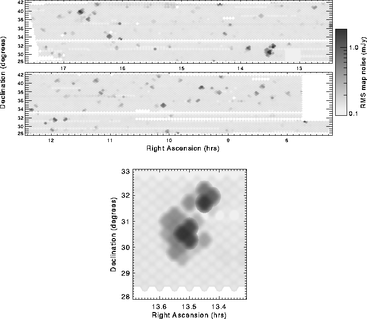
Figure:
RMS sensitivity in the FIRST survey area. Regions of higher noise
(dark areas) occur near very bright sources due to incompletely CLEANed
sidelobes. (a) Entire area covered during 1993 and 1994 observing
campaigns. (b) Blowup of the region around the 14 Jy source 3C286.
Note also the scalloped edges of the survey area.
The method used to calculate sensitivity in the coverage map is also
used to establish a ![]() threshold below which sources are
discarded from the catalog (§ 4)).
When there is no source at a given
position, the coverage map can be used to determine the maximum
brightness of any uncataloged source near that position; including
the CLEAN bias (§ 4.3),
threshold below which sources are
discarded from the catalog (§ 4)).
When there is no source at a given
position, the coverage map can be used to determine the maximum
brightness of any uncataloged source near that position; including
the CLEAN bias (§ 4.3),
![]() mJy.
Note, however, that this
noise estimate is based not on a calculated value for the local RMS in
each coadded image, but on the weighted combination of noise values
derived from the whole-image RMS for each grid map that
contributes to that image. Since the effective noise in a grid map can
vary across the image, owing, for example, to incompletely CLEANed
bright and/or extended sources, the actual RMS in a particular coadded
image may differ by a small amount from the coverage map value. Thus,
while this map is a good representation of the overall survey coverage,
it should not be used to establish a definitive upper limit to the
radio flux density from a given location in the sky; rather, the flux
density in the relevant coadded image should be measured directly.
mJy.
Note, however, that this
noise estimate is based not on a calculated value for the local RMS in
each coadded image, but on the weighted combination of noise values
derived from the whole-image RMS for each grid map that
contributes to that image. Since the effective noise in a grid map can
vary across the image, owing, for example, to incompletely CLEANed
bright and/or extended sources, the actual RMS in a particular coadded
image may differ by a small amount from the coverage map value. Thus,
while this map is a good representation of the overall survey coverage,
it should not be used to establish a definitive upper limit to the
radio flux density from a given location in the sky; rather, the flux
density in the relevant coadded image should be measured directly.
The coverage map RMS sensitivity ranges from 0.075 to 1.86 mJy/beam
with a median value of 0.141 mJy/beam over the 1550 ![]() in
the completed survey region; 95% of this area has a
in
the completed survey region; 95% of this area has a ![]() sensitivity of <0.17 mJy/beam. The map is available through the
FIRST WWW homepage (https://sundog.stsci.edu).
sensitivity of <0.17 mJy/beam. The map is available through the
FIRST WWW homepage (https://sundog.stsci.edu).